Recently in 健身 Category

Today's road biking

| No Comments | No TrackBacks

So I tried to use EveryTrail on my iPhone to track my biking trail. LIke all other similar softwares, it uploads the trail to its own website and let you and public view on the website, but not within the software it self. That’s ok.

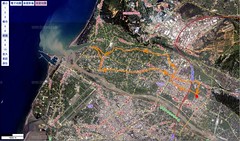
Somehow the starting point of the map is seriously wrong. Maybe I pushed the start button too early while I was still too close to the apartment building, but still, that offset is like 20km, longer the my whole trail. Very bad.

Bike ride: 從竹北到台中

| 1 Comment | No TrackBacks


View Larger Map

這條路線從竹北出發,到台中市區結束。跟據安裝在腳踏車上的里程計,總長度為 108 公里。

由於走海邊的路線,基本上從竹北到清水這麼一大段都很容易,中間高度變化比較多的部份約莫是在後龍到苑里一帶。到清水時,里程大約為 90 公里。

但從清水經大雅的這段台10線可就要命了。大約有連續 6 公里的上坡路,坡度還不小,又是在體力已經耗盡的最後路段,一開始上坡我就雙腿同時抽筋了。於是沿線一直休息,大約每騎 20 分鐘就要休息 10 分鐘才有辨法繼續騎下去。結果台 10 線的上坡就花去我 1.5 小時左右。

現在回顧起來,為了避開最後這段上坡地獄、也許應該在中途某處先切到台 13 線或台 3 線。最起碼能夠在體力狀況尚可之時爬坡,別將痛苦集中到最後。

另外就是,這段海線能補給飲料的店家真是少得可憐,可能不到五處,也就是每 20 公里才有機會看到商店,因此喝水不能喝太快。

Today's bike ride

| No Comments | No TrackBacks

Bike Ride 2008/08/06

| No Comments | No TrackBacks

檢視較大的地圖

竹北→芎林→橫山→關西→新埔→竹北。約 50km、約需 2.5小時。

在關西折返時,於台三線接118線的路口走岔了、差點就一路走到龍潭去了..

這條路線的起伏並沒有想像中的大,只有在橫山進入台三線時有明顯的在騎山路的感覺。本來沒有想到會騎這麼久,騎到橫山時已經開始天黑了,因此在台三線上幾乎摸黑騎了三公里左右。由於 118 新埔至關西這一段的路燈也不多,下午出發的話,最好還是準備個頭燈照路比較方便。

Labels: ,

2008/07/31 單車騎乘路線

| No Comments | No TrackBacks

單車騎乘路徑 2008/07/15

| No Comments | No TrackBacks

檢視較大的地圖

一個小時,19.7 公里。11:30 出發(我真是自瘧)。

Labels: ,

今日腳踏車運動路線...

| No Comments | No TrackBacks

今天的單車運動路線

| 2 Comments | No TrackBacks

檢視較大的地圖


手動慢慢做的地圖,有些小錯誤... 有夠麻煩的。該買個 GPS tracker 了嗎

Labels: ,

Cycling of 2006,Mar,22

| No Comments | No TrackBacks
bike-route

22 Km, 70m